ATMOSPHERIC SCIENCE / WEATHER PATTERNS EXPLAINED
The High-Altitude Winds That Steer Our Weather
Discover how powerful air currents high above Earth influence winter cold outbreaks, prolonged summer heat, and the paths followed by major storm systems.
Why can one part of the United States experience unusually warm weather while another region faces freezing temperatures? Why do some storm systems travel across the country in quick succession, while others seem to stall for days?
One important part of the answer lies several miles above the ground, where powerful winds race through the upper atmosphere.
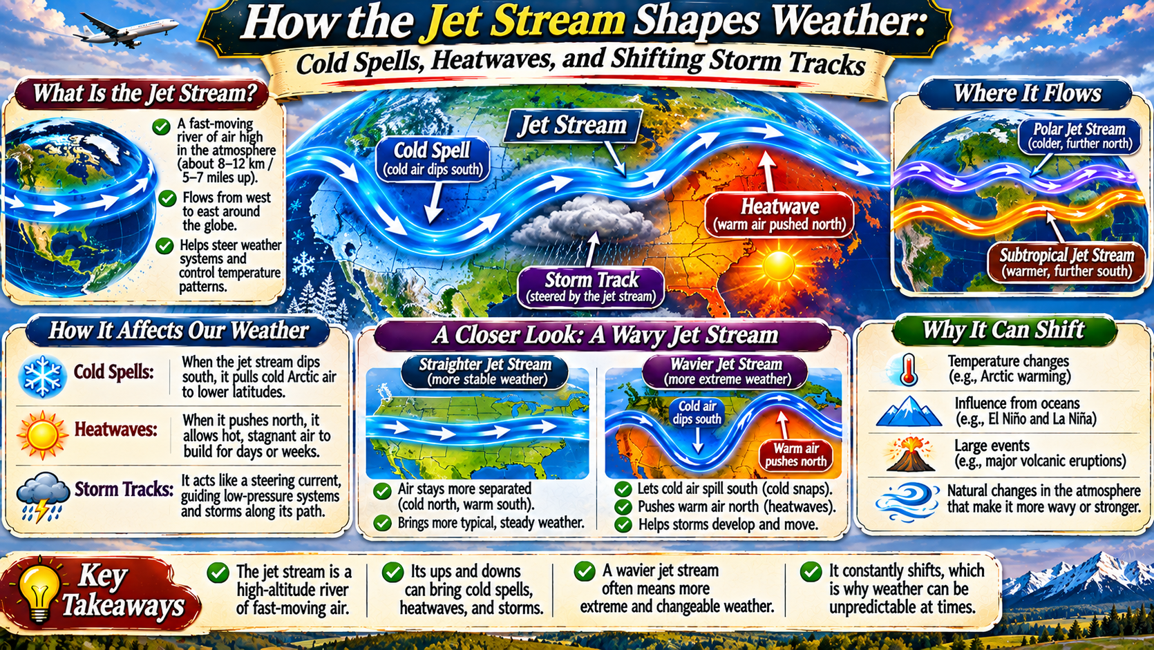
These winds form the jet streams—relatively narrow bands of fast-moving air that influence large-scale weather patterns across the planet. Their position and shape help determine where cold air moves, where warm conditions persist, and how weather systems develop and travel.
Jet streams do not control every weather event, but they are essential to understanding atmospheric circulation, especially across the middle latitudes of North America, Europe, and Asia.
What Is the Jet Stream?
A jet stream is a concentrated band of strong winds located high in the atmosphere, generally near the boundary between the troposphere and stratosphere. This region is close to the altitude where many commercial aircraft cruise.
Jet streams often occur roughly 5 to 9 miles above Earth’s surface, although their height varies with latitude, season, and atmospheric conditions. Their winds generally flow from west to east in the middle latitudes, but the path is rarely straight.
Instead, jet streams form broad curves and waves as they circle the globe. Wind speeds can exceed 100 miles per hour, with particularly strong sections reaching much higher speeds.
These fast-moving currents are not permanent tubes of air with fixed boundaries. They shift, strengthen, weaken, and sometimes split as atmospheric conditions change.
ATMOSPHERIC FIELD NOTE
The Jet Stream Is a Moving Boundary, Not a Stationary Line.
Its changing position reflects differences in atmospheric temperature, pressure, and circulation. Those shifts help explain why weather patterns can change dramatically from one week to another.
How Jet Streams Form
Jet streams develop because Earth is heated unevenly. Tropical regions receive more direct solar energy than polar regions, creating large differences in temperature between air masses.
These temperature contrasts are associated with differences in atmospheric pressure that become especially important at higher altitudes. The resulting pressure-gradient forces help accelerate winds.
Earth’s rotation also influences the direction of atmospheric motion through the Coriolis effect. Together, these processes help produce strong winds that generally flow west to east.
The strongest jet streams often develop where horizontal temperature contrasts are pronounced. This is why their location and strength can change significantly between seasons.
Jet streams are typically stronger during winter, when the temperature contrast between polar and lower-latitude air is often greater.
Polar Jet Stream vs. Subtropical Jet Stream
Two major jet streams are particularly important in each hemisphere: the polar jet stream and the subtropical jet stream.
UPPER-LEVEL CURRENT 01
Polar Jet Stream
Typically found near the boundary between colder polar air and warmer midlatitude air. It plays a major role in the movement and development of weather systems across North America.
UPPER-LEVEL CURRENT 02
Subtropical Jet Stream
Generally located farther toward the equator at higher altitudes. It influences upper-level wind patterns and can contribute to the development of storms and precipitation.
The two currents may interact, and their relative positions vary throughout the year. In the United States, the polar jet is especially important for understanding many winter temperature swings and storm tracks.
Why the Jet Stream Develops Large Waves
Although jet streams generally move from west to east, their paths often bend northward and southward. These large-scale atmospheric waves are related to Rossby waves.
Rossby waves arise from the dynamics of rotating fluids and the way the Coriolis effect varies with latitude. They are a fundamental part of planetary atmospheric circulation.
On weather maps, a northward bulge in the jet stream is commonly associated with an upper-level ridge. A southward dip is associated with an upper-level trough.
Ridges and troughs influence the distribution of temperature, pressure, and weather systems. When the wave pattern changes, conditions at the surface can change as well.
WEATHER MAP INTERPRETATION
A northward extension of higher upper-level heights, often associated with warmer and more settled conditions beneath it.
A southward extension of lower upper-level heights, often associated with cooler air and more unsettled weather.
How the Jet Stream Contributes to Cold Spells
During winter, the polar jet stream helps separate colder air at high latitudes from relatively warmer air farther south. This separation is not a rigid barrier, but the jet’s position often provides clues about where contrasting air masses are located.
When a large trough extends southward across North America, cold air can spread into regions that normally experience milder conditions. Depending on the weather pattern, these outbreaks may reach the central, eastern, or southern United States.
Strong surface high-pressure systems can reinforce the movement of cold air. Snow cover, nighttime cooling, and local geography may further influence temperatures.
It is important to distinguish the jet stream from the polar vortex. The polar vortex refers to large-scale circulation around the poles, particularly in the stratosphere during winter. Interactions between stratospheric and tropospheric circulation can affect some cold outbreaks, but not every cold spell is caused by a polar vortex disruption.
How Jet Stream Patterns Influence Heatwaves
Jet stream patterns also help explain prolonged periods of unusually hot weather. A persistent upper-level ridge can support the development of a strong high-pressure system over a region.
Under certain conditions, sinking air within a high-pressure system warms as it compresses. Clear skies can allow strong daytime solar heating, while dry soils may intensify surface temperatures by reducing evaporative cooling.
If the atmospheric pattern changes slowly, these conditions can persist for several days or longer.
Such events are sometimes associated with what meteorologists describe as a heat dome, although the term is informal and does not refer to a single standardized atmospheric structure.
Jet stream position is only one factor in heatwave development. Land conditions, humidity, seasonal temperatures, and the broader climate background also matter.
Why Storms Often Follow the Jet Stream
Many midlatitude storms develop and travel within broad atmospheric patterns associated with the jet stream. These storms are often called extratropical cyclones.
Upper-level winds help steer weather systems, while differences in temperature and pressure contribute to storm development.
Particularly strong sections of the jet stream, called jet streaks, can create regions of upper-level divergence that favor rising air under suitable conditions.
Rising air may support cloud formation and precipitation when sufficient moisture is available.
However, the jet stream does not act like a conveyor belt that mechanically pulls every storm along the same path. Storm motion results from interactions across several atmospheric levels.
This is why meteorologists analyze jet stream patterns alongside surface pressure systems, humidity, and other measurements when forecasting storms.
How Shifting Storm Tracks Affect the United States
The position of the jet stream can influence which parts of the United States experience frequent storms and which remain comparatively dry.
When the main storm track is displaced northward, some northern regions may experience more frequent passing weather systems. Areas farther south may remain under relatively stable conditions, depending on the broader circulation pattern.
A more southerly storm track can bring precipitation and winter storms into regions that might otherwise remain dry.
For example, the paths of winter storms across the Great Plains, Midwest, and eastern United States are influenced by upper-level circulation.
Along the Atlantic Coast, the interaction of upper-level troughs, coastal temperature contrasts, and moisture can contribute to the development of powerful nor’easters.
Because storm tracks shift from week to week and season to season, their effects vary considerably.
What Happens When Weather Patterns Become Blocked?
Sometimes the atmosphere develops a persistent arrangement of high- and low-pressure systems that slows the usual progression of weather patterns.
This phenomenon is known as atmospheric blocking.
A blocking high-pressure system can remain in place for an extended period, disrupting the normal west-to-east movement of weather systems.
Depending on its location, blocking may contribute to prolonged heat, drought, cold conditions, or repeated rainfall.
For example, a stationary ridge can help maintain hot weather, while a slow-moving low-pressure system may produce persistent precipitation nearby.
Blocking patterns are especially important because the duration of extreme weather can be as significant as its intensity.
Jet Stream Patterns and Their Weather Effects
| Jet Stream Pattern | Atmospheric Effect | Possible Surface Weather |
|---|---|---|
| Southward Trough | Cooler air extends toward lower latitudes | Cold spells and unsettled weather |
| Persistent Ridge | High-pressure conditions may persist | Heatwaves and dry conditions |
| Strong Jet Streak | Enhanced upper-level wind dynamics | Potential storm development |
| Northward Storm Track | Storm systems favor higher latitudes | Regional changes in precipitation |
| Atmospheric Blocking | Weather patterns progress slowly | Prolonged hot, cold, wet, or dry periods |
Does Climate Change Affect the Jet Stream?
Scientists are studying how long-term climate change may influence jet streams and large-scale atmospheric circulation.
The Arctic has warmed faster than the global average in recent decades, changing temperature contrasts in parts of the atmosphere. These changes may influence some circulation patterns.
However, the relationship between Arctic warming, jet stream waviness, atmospheric blocking, and extreme weather remains an active research area.
Different studies have reached different conclusions about the strength, consistency, and causes of particular circulation changes.
It would therefore be misleading to claim that climate change has simply made the jet stream permanently weaker or more wavy everywhere.
What is well established is that a warmer climate raises the background temperature against which heatwaves occur. Jet stream patterns can influence where and when those events develop, while long-term warming can increase their intensity.
How Meteorologists Track the Jet Stream
Meteorologists study jet streams using observations and computer-based atmospheric models.
Weather balloons carry instruments that measure temperature, pressure, humidity, and winds through different atmospheric layers. Aircraft observations and satellite data provide additional information.
Forecast models combine observations with physical equations to estimate how atmospheric conditions may evolve.
Jet streams are commonly examined on upper-air weather maps, including charts near the 250-millibar or 300-millibar pressure levels.
These maps reveal the location of strong winds, major ridges and troughs, and other features relevant to forecasting.
Because the atmosphere is complex, forecasts become less certain farther into the future. Small differences in initial conditions can eventually produce substantially different outcomes.
Why Jet Streams Matter Beyond Weather Forecasting
Jet streams also influence aviation. Aircraft flying with strong upper-level tailwinds may complete certain routes more quickly, while headwinds can increase travel time and fuel requirements.
Airlines consider wind forecasts when planning routes, although safety, airspace restrictions, and other operational factors also affect flight paths.
Strong wind shear near jet streams can contribute to clear-air turbulence, which may occur without visible storm clouds.
Understanding upper-level winds therefore helps aviation planners anticipate both favorable winds and potentially hazardous conditions.
Frequently Asked Questions
What causes the jet stream?
Jet streams develop through large-scale temperature and pressure differences, together with the effects of Earth’s rotation.
How fast does the jet stream move?
Wind speeds vary, but strong jet streams can exceed 100 miles per hour, with especially intense sections reaching substantially higher speeds.
Can the jet stream cause a cold spell?
A southward dip in the polar jet can help cold air move into lower latitudes, contributing to unusually cold conditions.
How does the jet stream affect heatwaves?
Persistent upper-level ridges can support prolonged high-pressure patterns that favor hot weather under suitable conditions.
Does the jet stream control hurricanes?
Tropical cyclones are primarily steered by surrounding atmospheric circulation. Jet stream interactions can become important as storms move toward higher latitudes or transition into extratropical systems.
Is the jet stream the same as the polar vortex?
No. They are distinct atmospheric circulation features, although interactions between them can sometimes influence winter weather.
Does the jet stream change with the seasons?
Yes. Its strength and position vary seasonally, partly because temperature contrasts between air masses change throughout the year.
Final Thoughts
The jet stream is one of the atmosphere’s most influential large-scale features. These powerful upper-level winds help shape the movement of air masses, the development of storms, and the distribution of weather across entire continents.
Southward troughs can contribute to cold outbreaks, while persistent ridges may favor heatwaves. Changes in jet stream position can shift storm tracks and alter regional precipitation patterns.
Although jet streams are only one part of a complicated weather system, understanding their movement provides valuable insight into why conditions can vary so dramatically from place to place.
The next time a forecast mentions a dipping jet stream or a stubborn high-pressure ridge, remember that the weather at ground level is connected to powerful atmospheric processes occurring miles overhead.